
Data / Licensed data
Licensed data
Data we maintain for paying customers: kept current, delivered into your own tools, and priced by coverage and use. Every value carries its source, the version of that source, and the date it took effect. Where we have no coverage, the product says so. Open datasets, free under an open license, are listed separately.
Products
Products
-
Site screening evidence
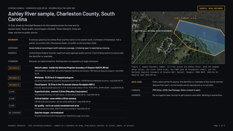
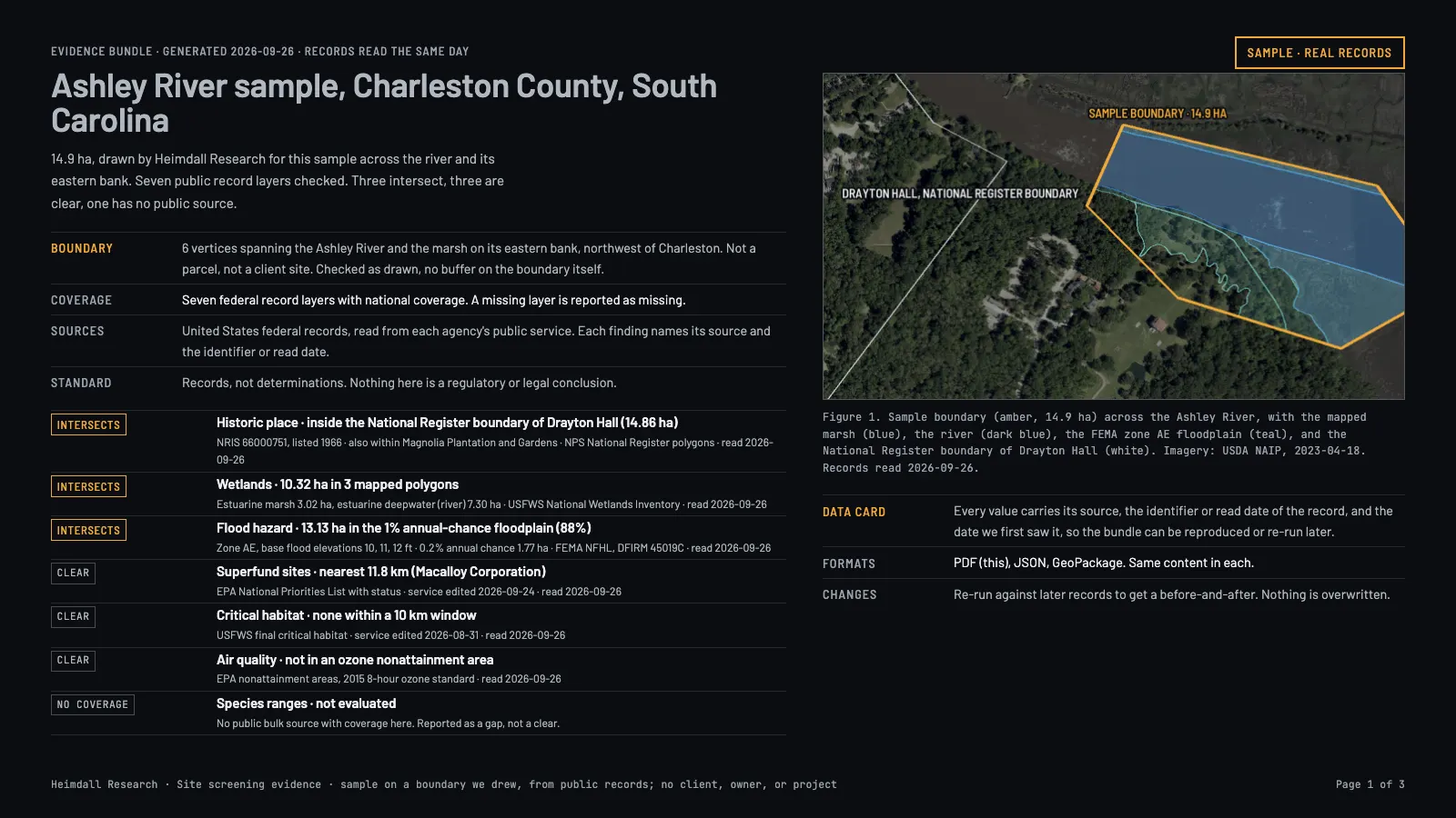
For a boundary you supply, every federal record that touches it: wetlands, floodplains, habitat, contaminated sites, air-quality areas, historic places, and prior federal reviews, each with its source, version, and date.
For Environmental consultants, engineering firms, developers, and GIS teams who screen many sites and want the evidence inside their own tools.
Sample: a boundary we drew across the Ashley River, South Carolina, checked against seven federal layers on 26 September 2026.
-
Federal review milestone feed
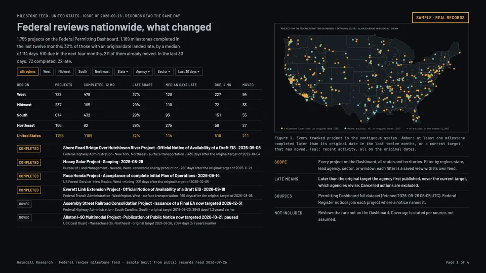
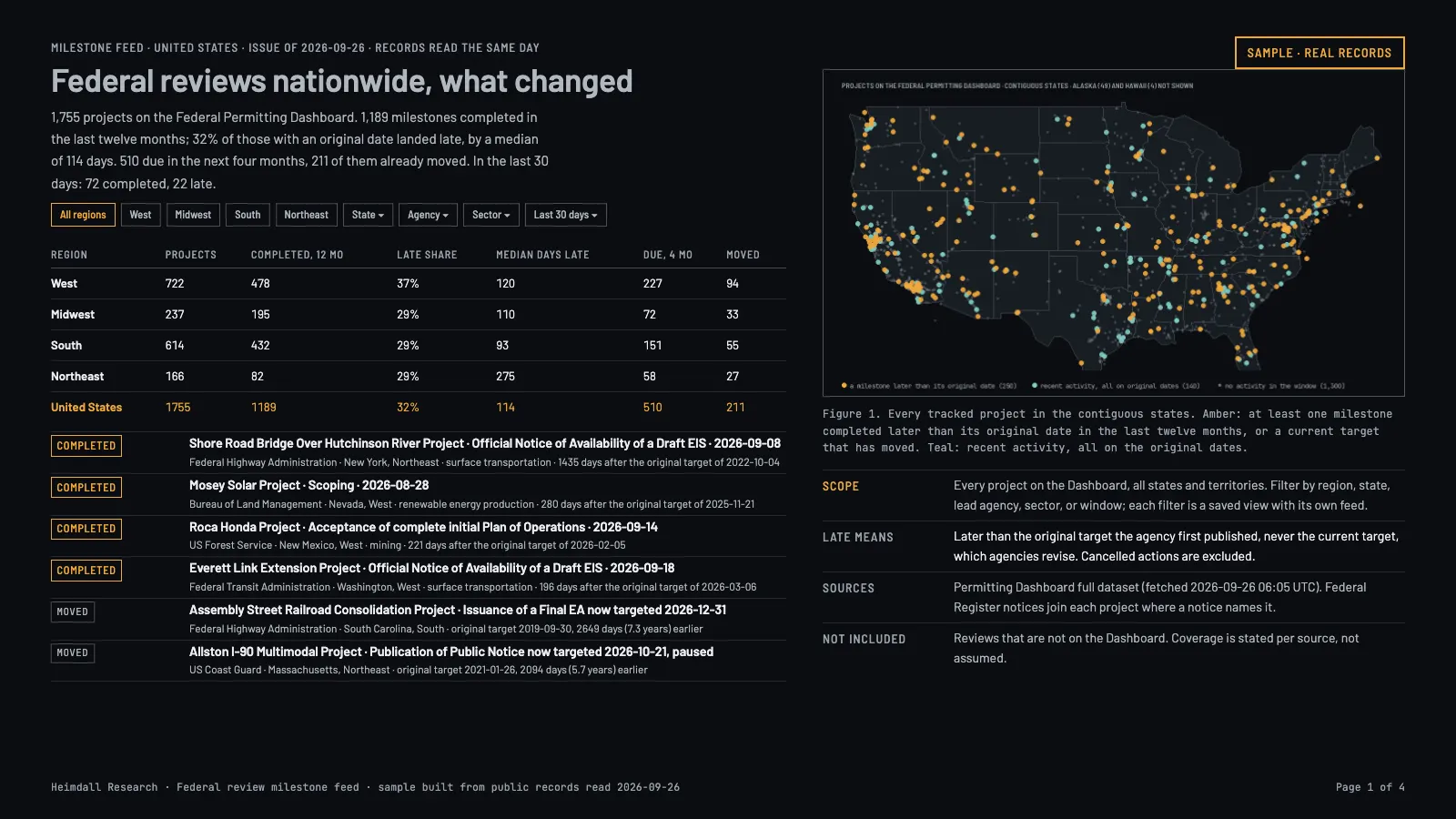
Milestones, notices, and schedule slippage for federal environmental reviews nationwide, delivered as they change and filtered by region, state, agency, or sector.
For Developers, lenders, law firms, and public agencies whose schedules depend on a federal review.
Sample: the national issue of 26 September 2026, every project on the Federal Permitting Dashboard.
-
Portfolio monitoring
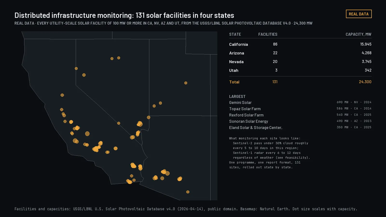
Your saved boundaries checked against every source update, with a before-and-after for each change and the source version on both sides.
For Owners and operators of many sites: utilities, energy portfolios, infrastructure funds, and the firms that serve them.
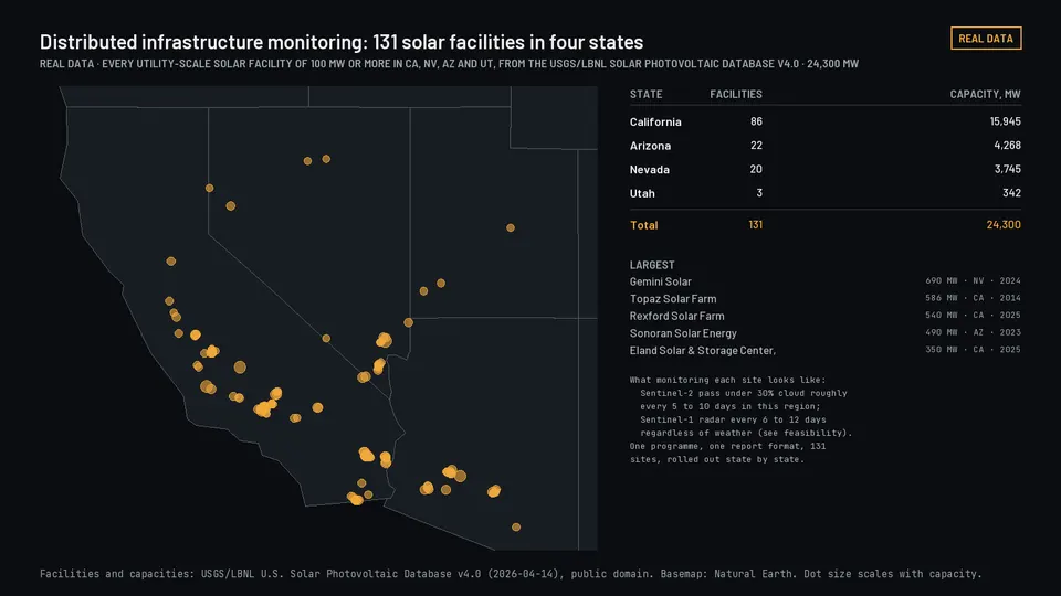
Illustration: a real portfolio, every solar facility of 100 MW or more in four states, from the USGS database.
-
Water observation histories
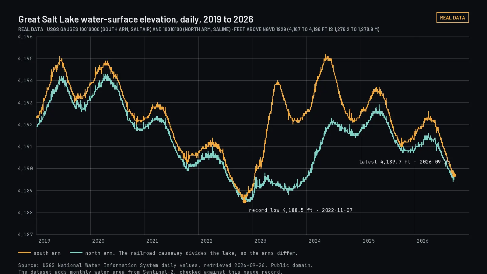
One consistent history per lake, reservoir, or gauge you name: level, surface extent, storage, and flow, with units reconciled and a quality flag on every value.
For Water managers, irrigation districts, utilities, and researchers who track many water bodies across several agencies' records.
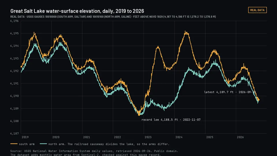
Illustration: Great Salt Lake elevation from USGS gauges, the public record the open dataset is checked against.
Existing customers: sign in to the customer system. Sign-in, keys, and delivery run there, separately from this website.
Specifications
Coverage, cadence, and delivery
Site screening evidence For a boundary you supply: which wetlands, floodplains, streams, critical habitat, contaminated sites, air-quality areas, historic places, and prior federal reviews touch it, each with its source, version, date, and distance National for the seven federal record layers; state and local layers are added state by state. The coverage table ships with every result On request; sources refreshed on their own schedules API, file export, PDF evidence bundle AvailableFirst customers onboarding
Draw or upload a boundary and get back findings per layer: what intersects, how far away it is, which version of which public record says so, and where we simply have no data. Built for environmental consultants, engineering firms, and GIS teams who run this for many sites and want the evidence inside their own systems. Findings report what public records say; they are not regulatory determinations.
Federal review milestone feed Milestones, notices, and schedule slippage for federal environmental reviews, as they change. Filter by region, state, lead agency, or sector; each filter is a saved feed All 50 states and the territories; records back to the 1990s, mapped footprints for a minority of projects and stated as such Daily change feed API with cursor pagination, scheduled report AvailableFirst customers onboarding
A running record of federal environmental review activity: which milestones were hit or missed, which notices were published, how long comparable reviews took, and whether they were challenged. Each entry carries the record it came from and the date we first saw it, so every change reflects the source record and none of it is our interpretation. For developers, lenders, law firms, and anyone whose schedule depends on a federal review.
Portfolio monitoring Your saved boundaries checked against every source update, with a before-and-after for each change Same as site screening Nightly API, scheduled report, alert by email PlannedAfter the two products above
Screening answers "what is here today." Monitoring answers "what changed since the baseline you saved," with the source version on both sides of the change. It is sold per portfolio with a site cap, so costs are predictable.
Water observation histories One consistent history per lake, reservoir, or gauge you name: level, surface extent, reported storage, and flow, with units and datums reconciled and a quality flag on every value Western United States first; satellite extent where our open lake pipeline covers the water body Monthly, with provisional in-month values CSV, Parquet, API PlannedAfter the Western Terminal Lakes release, est. Dec 2026
The same pipeline as our open Western Terminal Lakes dataset, applied to your list of sites and joined to the gauge and reservoir records that describe them. The open release stays free; the paid part is your site list, the joins, the cadence, and support.
Select a row for a summary. Status and coverage are stated as they are today; when coverage grows, the product's own coverage table changes before this page does.
Product standard
What every product includes
-
A A small block of metadata attached to every response: which source, which version of it, when it took effect, and when we first saw it. on every response
Source, source version, effective date, and first-seen date on each value, so two people looking at the same result a month apart can tell whether the world changed or the record did.
-
Coverage stated, gaps flagged
A result distinguishes "nothing intersects" from "no coverage here" from "not evaluated." A missing layer is reported as missing.
-
Records, not conclusions
We report what a public record says and where it lives. We do not make regulatory determinations, legal judgments, or predictions about outcomes.
-
Versioned, with a changelog
Schema and method carry a version. Changes are listed, and earlier versions remain readable for the life of your agreement.
-
Source attribution
Inputs are public government records and open satellite programs unless your agreement says otherwise. Any attribution a source requires travels with the data.
-
A sample before a contract
Every product starts with a real output on a boundary, agency, or site list you pick, so you judge the data before you pay for it.
Terms
How licensing works
- License
- A written data license per product and customer. It states permitted use (internal, client deliverables, redistribution, derived products), the number of users or sites, the term, and what happens to the data when the term ends. These products are not covered by the open license on our free datasets.
- Pricing
- Priced by coverage, update frequency, permitted use, and delivery method. A scoped first engagement comes first; a subscription follows. Self-serve sign-up with a free tier follows once the customer system opens. See how it fits with services.
- Delivery
- Through a separate customer system with its own sign-in, keys, and usage records, not through this website. Keys are scoped to your organization and product and can be revoked or rotated at any time.
- Sources and rights
- We keep a register of every input: its license, its access terms, and what we may deliver downstream. A source that does not permit redistribution is used only to compute values we are allowed to deliver, and the register says so.
- Your data
- Boundaries, site lists, and results you send us stay yours, are used only to deliver your product, and are deleted at the end of the term on request.
- Ask
- To get started or request a quote, tell us the product, the area, and how you will use the data. Existing customers sign in to the customer system.
Licensed data
Getting started
Tell us the product and the scope. We send terms, a first output with its data card, and a quote. Self-serve sign-up with a free tier follows once the customer system opens. Existing customers sign in here.