
Water observation histories
One consistent history per lake, reservoir, or gauge you name: level, surface extent, storage, and flow, with units reconciled and a quality flag on every value.
For
Who it is for
Water managers, irrigation districts, utilities, and researchers who track many water bodies across several agencies' records.
Product
What you get
The same pipeline as our open Western Terminal Lakes dataset, applied to your list of sites and joined to the gauge and reservoir records that describe them. The open release stays free; the paid part is your site list, the joins, the cadence, and support.
- What you get
- One consistent history per lake, reservoir, or gauge you name: level, surface extent, reported storage, and flow, with units and datums reconciled and a quality flag on every value
- Coverage
- Western United States first; satellite extent where our open lake pipeline covers the water body
- Cadence
- Weekly, with the monthly open series alongside
- Delivery
- CSV, Parquet, API
Monitored now
Lakes we already monitor
| Water body | State | Gauge record joined |
|---|---|---|
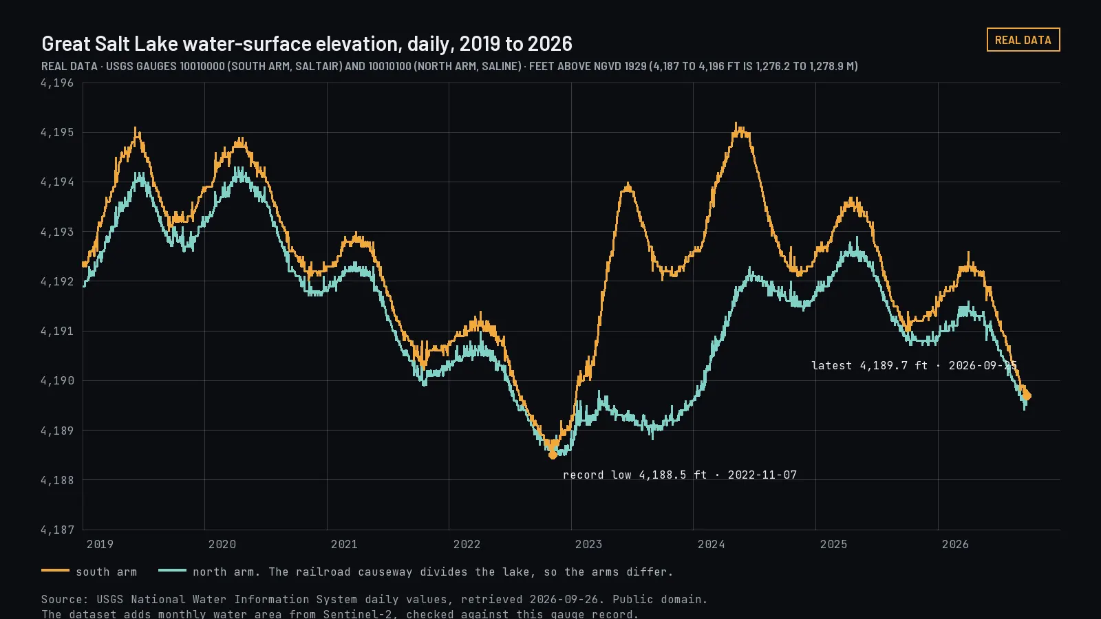
| Great Salt Lake, north arm | Utah | USGS 10010100, daily level |
| Great Salt Lake, south arm | Utah | USGS 10010000, daily level |
| Salton Sea | California | USGS 10254005, daily level |
| Mono Lake | California | No USGS series; satellite area only |
| Pyramid Lake | Nevada | USGS 10336500, periodic field readings |
| Walker Lake | Nevada | USGS 10288500, reported storage |
| Lake Abert | Oregon | USGS 10387150, daily level since 2023 |
Any water body
Any lake or reservoir you name
- What we can add
- Any lake or reservoir that satellites can see clearly, generally open water larger than about 10 hectares. We check smaller ones before quoting.
- What each history includes
- Satellite water area from Sentinel-2 imagery wherever the water body is visible, plus level, reported storage and flow from public gauge and reservoir records wherever those exist. Where no gauge exists, the history is satellite area only, and it says so.
- Choosing your sites
- One lake or reservoir, or a bundle of up to 25. Pick from the water bodies we already monitor, add any others by name, and we reply with the plan and a quote. At launch you choose them in the customer app by searching the list or drawing a boundary.
- New sites
- A water body we haven't monitored before is added to your plan with its full history back to 2019.
Request
Choose your lakes and reservoirs
Tools
Works with ArcGIS and your other tools
| Tool | How the data arrives | Status |
|---|---|---|
| Spreadsheets | CSV with one row per site per week: level, surface area, storage and flow where they exist, each with its unit, source and quality flag | Delivered with each update |
| ArcGIS and QGIS | Site locations and water outlines as GeoPackage or GeoJSON, joined to the CSV by site ID | Delivered with each update |
| Python and R | Parquet with the same columns as the CSV | Delivered with each update |
| Your own software | JSON time series through the API | After the lakes release |
Tell us which tools your team uses in the request form. Units can be delivered in feet and acre-feet or in meters and cubic meters.
Price
Price
- One lake or reservoir
- $240 a month, $690 a quarter, or $2,400 a year
- Up to 25
- $1,800 a month, $5,100 a quarter, or $18,000 a year
- Availability
- Opens after the Western Terminal Lakes release, estimated December 2026. You can send your site list now.
Start
Getting started
- Now
- Choose your lakes above and we reply with the scope, a sample and a quote.
- After the lakes release
- Sign up in the customer app, choose a plan from plans and prices, pay by card, bank account or invoice, and use the data through the API, the MCP server for AI assistants, or downloads. Estimated December 2026.
- Existing customers
- Sign in to the customer system.