
Site screening evidence
For a boundary you supply, every federal record that touches it: wetlands, floodplains, streams, habitat, contaminated sites, air-quality areas, historic places, and prior federal reviews, each with its source, version, and date.
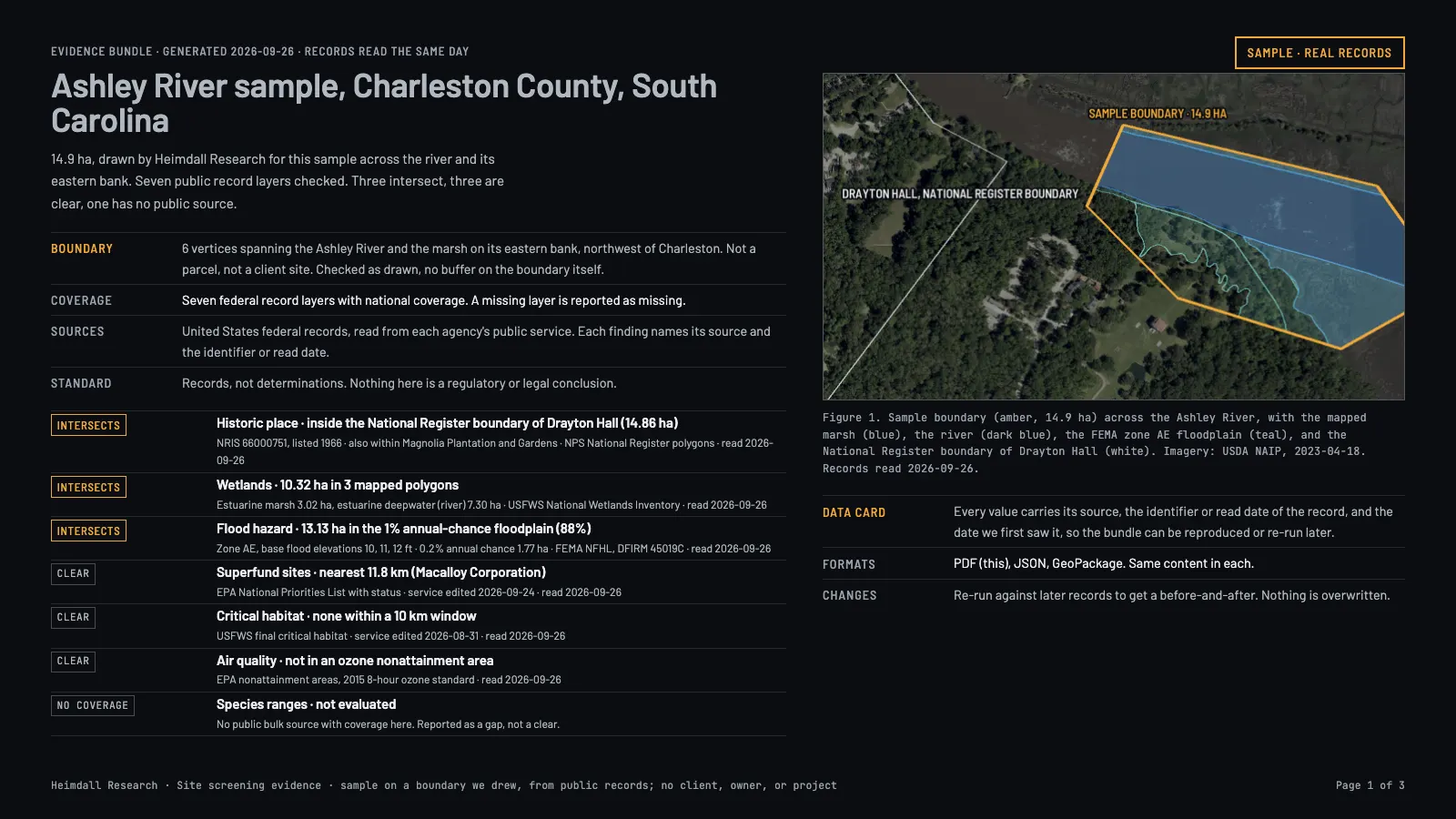
For
Who it is for
Environmental consultants, engineering firms, developers, and GIS teams who screen many sites and want the evidence inside their own tools.
Product
What you get
Draw or upload a boundary and get back findings per layer: what intersects, how far away it is, which version of which public record says so, and where we simply have no data. Built for environmental consultants, engineering firms, and GIS teams who run this for many sites and want the evidence inside their own systems. Findings report what public records say; they are not regulatory determinations.
- What you get
- For a boundary you supply: which wetlands, floodplains, streams, critical habitat, contaminated sites, air-quality areas, historic places, and prior federal reviews touch it, each with its source, version, date, and distance
- Coverage
- National for these federal records; state and local layers are added state by state. The coverage table ships with every result
- Cadence
- On request; sources refreshed on their own schedules
- Delivery
- API, file export, PDF evidence bundle
Integration
Works with ArcGIS and your other tools
| Tool | How the data arrives | Status |
|---|---|---|
| ArcGIS Pro | GeoPackage or file geodatabase with the boundary, every intersecting feature and a findings table, each feature carrying its source, version and date | Delivered with each result |
| ArcGIS Online and Enterprise | GeoJSON or a zipped shapefile you add as a hosted layer; findings as a CSV table joined by feature ID | Delivered with each result |
| QGIS and other desktop GIS | GeoPackage, GeoJSON or shapefile | Delivered with each result |
| Reports and reviews | PDF evidence bundle with the map, findings and source list | Delivered with each result |
| Your own software | JSON through the API, with the same fields as the files | October 2026 |
| Live layer in ArcGIS or QGIS | A standard OGC API – Features service your GIS adds once and refreshes, so saved sites update without re-importing | Planned |
Tell us which tools and formats your team uses in the request form, and each delivery is prepared that way. Layer names, field names and coordinate systems can match your existing standards.
Price
Price
- Pricing
- Priced to your scope: number of sites or feeds, update cadence and delivery. We reply with a quote.
- Enterprise
- Single sign-on at $250 a month per connection, invoices with net-30 terms, custom service agreements.
Start
Getting started
- Now
- Send us the request form and we reply with the scope, a sample and a quote. Get started.
- From October 2026
- Once your quote is agreed, your organization gets an account in the customer app. Pay by card, bank account or invoice, and use the data through the API, the MCP server for AI assistants, or downloads.
- Existing customers
- Sign in to the customer system.